Planning and researching driving routes in advance of an RV road trip is always sensible. You’re sensible, right? Isn’t that what everyone says about you? Anyhow, when you’re looking at RV routes in rugged, mountainous Utah, it’s absolutely essential to put on your sensible glasses and sensible shirt and get out a nice crisp notepad, because it’s time to do some route research.
The following routes represent just a few of Utah’s most dangerous roads for big RVs, along with some that have restrictions on vehicle size. Alternative routes to all these roads are available, so consider all your options before hitting the road. Advanced planning will help ensure your road trip memories are filled with Utah’s beautiful scenery, and not your white knuckles on the steering wheel.
Are You Ready for RV Driving in Utah?
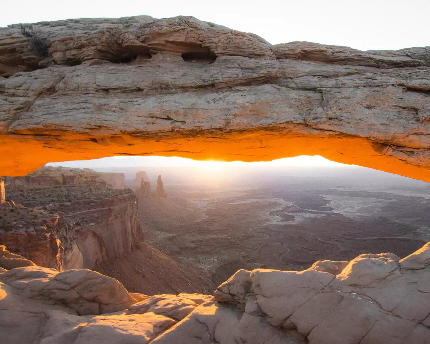
The good news is that most of Utah’s popular camping destinations — five national parks, 43 state parks and more than 20 million acres of public lands — are readily accessible by road. However, some routes in Utah aren’t ideal for RVs, even when they’re being driven by cautious drivers with a notepad full of detailed directions. Weather conditions make some Utah roads totally off-limits in winter. This is good because there’s always someone (not you) who sees slick, icy tarmac as a personal challenge. Other roads are best avoided due to blind curves, steep grades and low-clearance bridges or tunnels. If these features worry you driving a car, then they’ll be terrifying in a big RV. In fact, your personal comfort level with driving your RV on trickier routes is the No. 1 factor to consider while route planning. It’s especially important if you’re a new or inexperienced RV driver. It’s totally OK to be nervous about handling a large vehicle, and to plan your entire vacation around easy driving routes. Honestly, nobody’s judging you. Even the most confident drivers have their limits. It’s better to figure out what those limits are while you’re at home looking at maps, and not when you’re approaching a blind curve on some oh-so-scenic mountain pass.The Zion-Mt. Carmel Highway
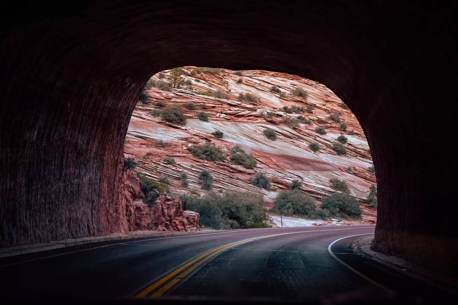
The Zion-Mount Carmel Highway (S.R. 9) is a National Scenic Byway that cuts from east to west through the heart of Zion National Park. As one of Utah’s most spectacular driving routes, it’s lined with majestically sculpted red rock formations overlooking desert sagebrush and pines. It’s the kind of landscape that inspires arguments over the appropriate frequency of photo stops. Aah, memories! The 26-mile route begins just past the town of Springdale and the national park’s west entrance. It ends east of the park at Mount Carmel Junction on US Route 89. Some narrow switchbacks might be of concern for less experienced RV drivers. The major consideration for this RV route in Utah is the passage through the historic Zion-Mount Carmel Tunnel. The 1.1-mile tunnel is a miracle of 1920s engineering (the miracle being dynamite, expendable labor, and an old-timey nutjob can-do-it spirit). Given that those engineers of yore couldn’t envision Class A RVs, the tunnel is not very tall or wide. Therefore, the park service enforces traffic controls, with larger vehicles allowed through only during certain time slots. Get your RV measured at the park entrance by a ranger with a giant measuring tape (no?). If your vehicle is over 7 feet, 10 inches wide or 11 feet, 4 inches long, you’ll need to buy a permit for $15. Vehicles over 13 feet, 1 inch tall, 40 feet long (single vehicles) or 50 feet long (combined trailer and towing vehicle) aren’t permitted to go through the tunnel.Alternative Route
The Zion-Mount Carmel Highway is typically enjoyed as a scenic drive and visitor attraction in its own right. It’s also the most straightforward way to get from one side of the park to another. If you need to get from Springdale to Mount Carmel Junction or from the west side to the east side of Zion National Park without driving on the highway, longer alternative routes are available. You could head west from Springdale, then south on UT 59 to the Arizona border. UT 43 will take you to the eastern side of Zion via Coral Pink Sand Dunes State Park. This is a fantastic RV camping destination to add to your itinerary.(Some of) Scenic Byway 12
Utah 12, or Scenic Byway 12, spans 122.863 miles and connects two of Utah’s incredible national parks: Bryce Canyon and Capitol Reef. It’s one of the most spectacular RV routes in Utah, and most of it promises an easy, relaxing and unforgettably scenic drive. Numerous state parks and vast stretches of the Dixie National Forest line the route, along with the Grand Staircase-Escalante National Monument. Some visitors spend several days camping along Scenic Byway 12, while overachievers drive it in one day. The byway’s popularity indicates it’s generally safe to drive for RVs of all sizes, particularly during the summer. Novice drivers and those with larger RVs or trailers should be aware of hairpin turns and steep drop-offs that might be intimidating. Plenty of pull-outs and scenic overlooks allow you to take it easy with lots of breaks, calming deep breaths and childish refusals to get back in the RV. You’ll also be able to admire the landscape. Further, the route peaks at 9,000 feet, and while it’s open year-round, winter storms can cause temporary closures. The Boulder Mountain stretch, the highest part of the route, includes the steep, narrow and winding “Hogsback” section. It can be scary to drive at any time of year and is frequently icy in winter. Just don’t do it.Alternative Route
Utah 12 connects the towns of Panguitch in the west with Torrey in the northeast. Several alternative routes between the two are available, including US-89, UT-62 and UT-24; and US-89 and UT-24. Both options intelligently avoid the hairpin bends and steep grades featured along Utah 12. UT-24 is a faster, safer, happier route for RVs between Bryce Canyon and Capitol Reef national parks.The Moki Dugway
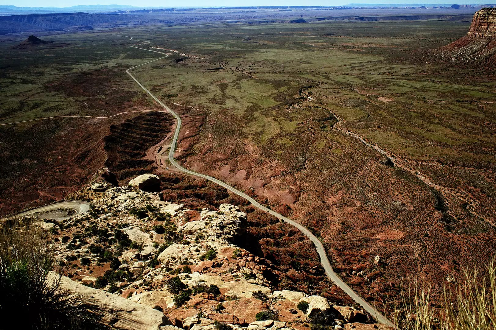
The Moki Dugway is a section of UT-261 in southeast Utah that connects the town of Bluff with the Natural Bridges National Monument. It’s frequently featured on lists of the most dangerous drives for RVs in the nation. You don’t get such a bro-riffic name as “Moki Dugway” by being relaxing to drive. This gravel road carved into a cliff face includes numerous steep twists, tight switchbacks and a steep ascent or descent of 1,200 feet from Cedar Mesa to the valley floor. Mules and mountain goats think twice about this route, so you probably should too. Drawn by breathtaking scenery, some RV drivers do tackle the Moki Dugway. Good for them? It’s certainly not recommended. Many drivers of regular vehicles find the route hair-raising enough. Also, the State of Utah recommends the road only be used by vehicles under 28 feet long and weighing less than 10,000 pounds.Alternative Route
Running parallel to UT-261 to the east is US 191. This alternative route runs from the town of Bluff all the way north to Moab and beyond. You can reach the northern end of UT-261 via SR 95, which joins US 191 just north of White Mesa.
Tips for Planning Safe RV Routes in Utah
- Make your dad proud and bookmark the Utah Department of Transportation site. Use it to look up current conditions and seasonal road closures.
- Avoid all steep mountain roads in winter, obviously.
- Make a note of your RV’s dimensions and weight, and keep that information handy. You need to know in advance if you can use RV routes in Utah with low-clearance bridges or weight restrictions.
- Use an RV-specific GPS or app. Regular maps don’t consider your vehicle’s size, so don’t use them as your only route-planning tool.
- Even if routes are clearly used by big trucks, that doesn’t mean they’re safe for casual RV drivers. Those trucks are driven by red-blooded professionals who are likely familiar with the roads.
- Utah folks are weirdly friendly but don’t rely on locals for directions. They might tell you how to get from A to B, but they won’t necessarily know if it’s a good route for RVs or your own experience level.
Are You Ready for RV Driving in Utah?
The good news is that most of Utah’s popular camping destinations — five national parks, 43 state parks and more than 20 million acres of public lands — are readily accessible by road. However, some routes in Utah aren’t ideal for RVs, even when they’re being driven by cautious drivers with a notepad full of detailed directions. Weather conditions make some Utah roads totally off-limits in winter. This is good because there’s always someone (not you) who sees slick, icy tarmac as a personal challenge. Other roads are best avoided due to blind curves, steep grades and low-clearance bridges or tunnels. If these features worry you driving a car, then they’ll be terrifying in a big RV. In fact, your personal comfort level with driving your RV on trickier routes is the No. 1 factor to consider while route planning. It’s especially important if you’re a new or inexperienced RV driver. It’s totally OK to be nervous about handling a large vehicle, and to plan your entire vacation around easy driving routes. Honestly, nobody’s judging you. Even the most confident drivers have their limits. It’s better to figure out what those limits are while you’re at home looking at maps, and not when you’re approaching a blind curve on some oh-so-scenic mountain pass.The Zion-Mt. Carmel Highway
The Zion-Mount Carmel Highway (S.R. 9) is a National Scenic Byway that cuts from east to west through the heart of Zion National Park. As one of Utah’s most spectacular driving routes, it’s lined with majestically sculpted red rock formations overlooking desert sagebrush and pines. It’s the kind of landscape that inspires arguments over the appropriate frequency of photo stops. Aah, memories! The 26-mile route begins just past the town of Springdale and the national park’s west entrance. It ends east of the park at Mount Carmel Junction on US Route 89. Some narrow switchbacks might be of concern for less experienced RV drivers. The major consideration for this RV route in Utah is the passage through the historic Zion-Mount Carmel Tunnel. The 1.1-mile tunnel is a miracle of 1920s engineering (the miracle being dynamite, expendable labor, and an old-timey nutjob can-do-it spirit). Given that those engineers of yore couldn’t envision Class A RVs, the tunnel is not very tall or wide. Therefore, the park service enforces traffic controls, with larger vehicles allowed through only during certain time slots. Get your RV measured at the park entrance by a ranger with a giant measuring tape (no?). If your vehicle is over 7 feet, 10 inches wide or 11 feet, 4 inches long, you’ll need to buy a permit for $15. Vehicles over 13 feet, 1 inch tall, 40 feet long (single vehicles) or 50 feet long (combined trailer and towing vehicle) aren’t permitted to go through the tunnel.Alternative Route
The Zion-Mount Carmel Highway is typically enjoyed as a scenic drive and visitor attraction in its own right. It’s also the most straightforward way to get from one side of the park to another. If you need to get from Springdale to Mount Carmel Junction or from the west side to the east side of Zion National Park without driving on the highway, longer alternative routes are available. You could head west from Springdale, then south on UT 59 to the Arizona border. UT 43 will take you to the eastern side of Zion via Coral Pink Sand Dunes State Park. This is a fantastic RV camping destination to add to your itinerary.(Some of) Scenic Byway 12
Utah 12, or Scenic Byway 12, spans 122.863 miles and connects two of Utah’s incredible national parks: Bryce Canyon and Capitol Reef. It’s one of the most spectacular RV routes in Utah, and most of it promises an easy, relaxing and unforgettably scenic drive. Numerous state parks and vast stretches of the Dixie National Forest line the route, along with the Grand Staircase-Escalante National Monument. Some visitors spend several days camping along Scenic Byway 12, while overachievers drive it in one day. The byway’s popularity indicates it’s generally safe to drive for RVs of all sizes, particularly during the summer. Novice drivers and those with larger RVs or trailers should be aware of hairpin turns and steep drop-offs that might be intimidating. Plenty of pull-outs and scenic overlooks allow you to take it easy with lots of breaks, calming deep breaths and childish refusals to get back in the RV. You’ll also be able to admire the landscape. Further, the route peaks at 9,000 feet, and while it’s open year-round, winter storms can cause temporary closures. The Boulder Mountain stretch, the highest part of the route, includes the steep, narrow and winding “Hogsback” section. It can be scary to drive at any time of year and is frequently icy in winter. Just don’t do it.Alternative Route
Utah 12 connects the towns of Panguitch in the west with Torrey in the northeast. Several alternative routes between the two are available, including US-89, UT-62 and UT-24; and US-89 and UT-24. Both options intelligently avoid the hairpin bends and steep grades featured along Utah 12. UT-24 is a faster, safer, happier route for RVs between Bryce Canyon and Capitol Reef national parks.The Moki Dugway
The Moki Dugway is a section of UT-261 in southeast Utah that connects the town of Bluff with the Natural Bridges National Monument. It’s frequently featured on lists of the most dangerous drives for RVs in the nation. You don’t get such a bro-riffic name as “Moki Dugway” by being relaxing to drive. This gravel road carved into a cliff face includes numerous steep twists, tight switchbacks and a steep ascent or descent of 1,200 feet from Cedar Mesa to the valley floor. Mules and mountain goats think twice about this route, so you probably should too. Drawn by breathtaking scenery, some RV drivers do tackle the Moki Dugway. Good for them? It’s certainly not recommended. Many drivers of regular vehicles find the route hair-raising enough. Also, the State of Utah recommends the road only be used by vehicles under 28 feet long and weighing less than 10,000 pounds.Alternative Route
Running parallel to UT-261 to the east is US 191. This alternative route runs from the town of Bluff all the way north to Moab and beyond. You can reach the northern end of UT-261 via SR 95, which joins US 191 just north of White Mesa.
Tips for Planning Safe RV Routes in Utah
- Make your dad proud and bookmark the Utah Department of Transportation site. Use it to look up current conditions and seasonal road closures.
- Avoid all steep mountain roads in winter, obviously.
- Make a note of your RV’s dimensions and weight, and keep that information handy. You need to know in advance if you can use RV routes in Utah with low-clearance bridges or weight restrictions.
- Use an RV-specific GPS or app. Regular maps don’t consider your vehicle’s size, so don’t use them as your only route-planning tool.
- Even if routes are clearly used by big trucks, that doesn’t mean they’re safe for casual RV drivers. Those trucks are driven by red-blooded professionals who are likely familiar with the roads.
- Utah folks are weirdly friendly but don’t rely on locals for directions. They might tell you how to get from A to B, but they won’t necessarily know if it’s a good route for RVs or your own experience level.